the traveler's resource guide to festivals & films
a FestivalTravelNetwork.com site
part of Insider Media llc.
Travel Info
City of Doha, Qatar
- Details
- Parent Category: Travel Info
- Category: Travel FAQ
- Published on Wednesday, 20 April 2011 04:15
- Written by Film Festival Traveler Staff
| Doha الدوحة ad-Dawḥa |
|
|---|---|
| — City and Municipality — | |
| Doha's modern towers | |
| Location of the municipality of Doha within Qatar. | |
Coordinates:  25°17′12″N 51°32′0″E 25°17′12″N 51°32′0″E |
|
| Country | |
| Municipality | Ad Dawhah |
| Established | 1850 |
| Area | |
| - City | 132 km2 (51 sq mi) |
| Population (2009) | |
| - City | 998,651 |
| - Density | 7,565.5/km2 (19,594.7/sq mi) |
| - Metro | 1,723,064 |
| Time zone | East Africa Time (UTC+3) |
State of Qatar
- Details
- Parent Category: Travel Info
- Category: Travel FAQ
- Published on Saturday, 16 April 2011 14:12
- Written by Wikipedia
City of Dublin, Ireland
- Details
- Parent Category: Travel Info
- Category: Travel FAQ
- Published on Wednesday, 13 April 2011 02:51
- Written by Film Festival Traveler Staff
| Dublin Baile Átha Cliath |
|||
|---|---|---|---|
| From upper left: Samuel Beckett Bridge, Grand Canal Theatre, International Financial Services Centre, Four Courts, The Custom House, and Dublin Castle. | |||
|
|||
| Motto: Obedientia Civium Urbis Felicitas "The citizens' obedience is the city's happiness"[1] |
|||
| Location of Dublin in Ireland | |||
Coordinates:  53°20′52″N 6°15′35″WCoordinates: 53°20′52″N 6°15′35″WCoordinates:  53°20′52″N 6°15′35″W 53°20′52″N 6°15′35″W |
|||
| Country | |||
| Province | Leinster | ||
| Government | |||
| - Type | City Council | ||
| - Headquarters | Dublin City Hall | ||
| - Lord Mayor | Gerry Breen | ||
| - Dáil Éireann | Dublin Central Dublin North Central Dublin North East Dublin North West Dublin South Central Dublin South East |
||
| - European Parliament | Dublin constituency | ||
| Area | |||
| - City | 114.99 km2 (44.4 sq mi) | ||
| - Urban | 921 km2 (355.6 sq mi) | ||
| Population | |||
| - City | 506,211 | ||
| - Density | 4,398/km2 (11,390.8/sq mi) | ||
| - Urban | 1,045,769 | ||
| - Metro | 1,661,185 | ||
| - Demonym | Dubliner, Dub | ||
| - Ethnicity (2006 Census) |
Ethnic groups[show]
|
||
| Time zone | WET (UTC0) | ||
| - Summer (DST) | IST (UTC+1) | ||
| Postal districts | D1-18, 20, 22, 24, D6W | ||
| Area code(s) | 01 | ||
| Website | www.dublincity.ie | ||
The City of Dallas
- Details
- Parent Category: Travel Info
- Category: Travel FAQ
- Published on Thursday, 31 March 2011 06:42
- Written by Film Festival Traveler Staff
| Dallas | |||
|---|---|---|---|
| — City — | |||
|
|||
| Nickname(s): "Big D" | |||
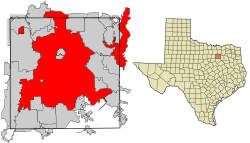
| Location in Dallas County and the state of Texas | |||
Coordinates:  32°46′58″N 96°48′14″W 32°46′58″N 96°48′14″W |
|||
| Country | United States | ||
| State | Texas | ||
| Incorporated | February 2, 1856 | ||
| Counties | Dallas, Collin, Denton,Rockwall, Kaufman | ||
| Government | |||
| • Type | Council-Manager | ||
| • Body | Dallas City Council | ||
| • Mayor | Mike Rawlings | ||
| Area | |||
| • City | 385.8 sq mi (999.3 km2) | ||
| • Land | 340.5 sq mi (881.9 km2) | ||
| • Water | 45.3 sq mi (117.4 km2) | ||
| Elevation | 430 ft (131 m) | ||
| Population (2010 United States Census)[1] | |||
| • City | 1,197,816 (9th U.S.) | ||
| • Density | 3,518/sq mi (1,358.2/km2) | ||
| • Metro | 6,371,773 (4th U.S.) | ||
| • Demonym | Dallasite | ||
| Time zone | Central (UTC-6) | ||
| • Summer (DST) | Central (UTC-5) | ||
| Area code | 214, 469, 972 | ||
| FIPS code | 48-19000[2] | ||
| GNIS feature ID | 1380944[3] | ||
| ZIP code prefix | 752,753 |
||
| Primary Airport | Dallas/Fort Worth International Airport- DFW (Major/International) | ||
| Secondary Airport | Dallas Love Field- DAL (Major) | ||
| Website | www.dallascityhall.com | ||
More Articles...
Subcategories
Newsletter Sign Up

Upcoming Events
No Calendar Events Found or Calendar not set to Public.


